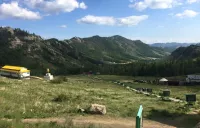
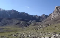
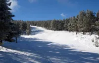
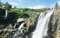
Places to visit

Filter by country

Altyn Emel KZ

Altyn Emel National Park is the largest and most famous nature conservation area in Kazakhstan, where the famous Singing Barkhan, the majestic Sak kurgans and the picturesque mountains of Aktau and Katutau are located. The park covers 523053 hectares and is located in the valley of the Ili River, 300 km away from the city of Almaty. Altyn Emel lies in the desert and mountain zones, where 1,800 species of plants grow. Within the park there are 78 species of mammals and 260 species of birds. On the spacious plains and mountain slopes gazelles, kulans and argali feel great. Apart from that, the park staff is doing a lot of work to weigh the endangered species like the Przhevalsky horse. Also in the national park there are radon sources.

Naryn reserve KG

Naryn Nature Reserve is located 40 km east of the town of the same name. It was established in 1983 and covers an area of 1080 km2. The reserve stretches along the northern flank of the Naryn Kyrka Toosuu Range, south of the Chong Naryn River. The altitude rises from 2000 meters to 4500 meters. The flora and fauna has become very rich, there are snow leopards, gray wolves, red foxes, Siberian ibex and argali, deer, Tien Shan brown bears and much more. 48 bird species have also been listed.

Juku valley KG

The Juku gorge (Zhuuku, Zauka, Jukku) gorge is the longest gorge on the Terskey Ala-Too ridge, famous for its diverse nature, beautiful views and wide expanse.

It is located on the southern coast of Lake Issyk-Kul, 70 kilometers from the city of Karakol.  In ancient times, this place was part of the routes of numerous merchants and travelers from various countries.

Despite the difficult relief of the gorge, Juuku was the only way from the Issyk-Kul valley to China for a long time.

The views in the gorge are very picturesque: there are red rocks, a dense Tien Shan spruce forest, several high-mountain lakes and a stormy river.

In the upper part, the gorge turns into a kind of high-mountainous desert, connecting with the famous Arabel plateau, full of lakes.

The fauna in the Juuku gorge is presented more widely and more numerous than in other gorges.  Here you can see whole herds of ibexes, argali, stone martens, roe deer, snowcocks, kekliks and bearded partridges.

Some of the ancient monuments located here are also of interest: rock paintings of the 6th-1st centuries BC, burial places of the ancient Turks, stone statues.

Khargush TJ

Khargush is a small hamlet in the Tajik Pamirs located 3900 meters south of the Khargush pass (4344 meters above sea level). Nothing really interesting, it's mostly a border guard post. It is also the intersection between the road that leads to the Khargush pass to the north, Lake Zorkul and its nature reserve to the east and the village of Langar to the west. There are a few guesthouses on the farms in the village. The panorama on the Vakhan range is impressive. Kohe Belandtarin peak is over 6200 meters, and its altitude is disputed, but it is one of the highest peaks in Afghanistan.

Mary TM

Mary is the third largest city in Turkmenistan, situated in the Karakum desert. It was an important centre on the Silk Road and the capital of a prosperous Margiana region. The city's name changed several times - Margush Maru, Margiane, Margao and Merv.

During the reign of the Turkmen Seljuk dynasty, Muslim architecture reached its apogee. At that time, the city of Merv was in an exceptional position, as an intellectual and cultural centre, a heritage from previous eras that played an important role.

Excavations at Sultan Kala bear witness to the high standard of urban life. The city is surrounded by the walls of the ancient fortress, in marvellous harmony with the mausoleum of Sultan Sanjar.

After the Mongol invasion, Merv was razed to the ground. Its ruins became sacred, and was given the name of ancient Merv.

Amir Timur's son Shahrukh rebuilt the city and in place of the old Merv, palaces, fortresses and squares were erected.

The most interesting monuments in Merv are the mausoleum of Sultan Sanjar Dar al-Ahira, the Shazriar Arch citadel, the ruins of the Abdullakhan Kala wall (15th century), the ruins of the Bayramalihan-Kala fortress and towers, the ruins of the Kiz-Kala fortress (6th-7th centuries BC), the mausoleums of the Sultans of Merv and Amir Timur and the ruins of the Kiz-Kala fortress (6th-7th centuries AD). ), the mausoleums of al-Hakim ibn Amir al-Jaafari and Buraydah ibn al-Husayn al-Islami (15th century, a place of pilgrimage), the mausoleum of Muhammad ibn Zayd (12th century), the Talhatan Baba complex with the Talhatan Baba mausoleums, the ruins of a Beni Makhan mosque ("Friday mosque", 7th-12th centuries. ), the mausoleum of Kiz-Bibi and numerous remains of baths, palaces, ceremonial halls and other facilities.

Today, Merv is included on UNESCO's World Heritage List as the best-preserved ancient centre on the Great Silk Road.

Djetimter valley KG

The Djetimter camp is not a permanent camp, but in summer it is a good location between the Juku valley and the Taragaï valley. In spring, some agencies set up a tent or yurt camp for ski touring, depending on demand.

It lies to the south of the road leading to the Kumtor gold mine and to the north of the Djetimbel pass, at an altitude of 3,994 metres, which crosses the Soek mountains.

This route is probably known from the time of the Silk Road caravans, the terrain is rocky and the path lies on the right bank of the Djetimter river.

Join us on Facebook!

And keep updated with our tour promotions, or follow us on