
Lake
Big Almaty lake
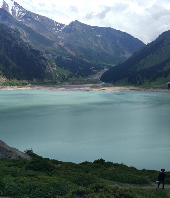
Almaty • Kazakhstan • 2509 m
The Big Almaty Lake is a high-mountain reservoir in the Zailiyskiy Alatau at an altitude of 2510 meters above sea level, 15 kilometers south of the city of Alma-Ata.
The basin of the lake is of tectonic origin, complex shape, with a general slope to the north. The lake is 1.6 km long and 0.75 to 1 km wide.
The length of the coastline is 3 km, the depth is 30-40 m, the area of the mirror is 0.9 square kilometers, the volume of the water mass is 14 million m³.
The maximum water level is in August, the minimum is in February. The level fluctuations reach 20 m. The shores of the lake are steep and steep. The Bolshaya Almatinka River flows into the lake from the south.
It is part of the Ile-Alatau National Park.
Like the vast majority of the Tien Shan lakes, it arose as a result of earthquakes.
Three main peaks rise above the lake, which can be seen from the northern end of the dam: Sovetov Peak (4317 m) - in the southeast, Ozerny Peak (4110 m) - in the south and Turist Peak (3954 m) - south-west of the lake ...
Access of tourists to the border zone of the border of Kazakhstan with the Kyrgyz Republic located above the lake is carried out without restrictions, a pass from the Ministry of Internal Affairs is not required. At a distance of 7-12 km from the border into the depths of the territory of the Republic of Kazakhstan, the operation of the border regime is excluded. Foreign citizens and stateless persons can visit these border areas for tourism purposes.
Source: Wikipedia